Geographic Map Terms
There are many geographical settings that make up the earth’s surface. Many of these characteristics can be seen on maps as well as from satellites because of their size. Many land formations are a result of weather and time, and often they can co-exist with one another. Read More...
◂Social Studies Worksheets and Study Guides Seventh Grade. Geographic Map Terms
Study Guide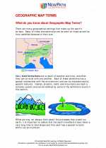 Geographic Map Terms
  Worksheet/Answer key
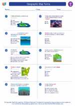 Geographic Map Terms Worksheet/Answer key
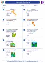 Geographic Map Terms Worksheet/Answer key
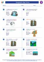 Geographic Map Terms
Worksheet/Answer keyWorksheet/Answer keyWorksheet/Answer keyThe resources above cover the following skills:
National Curriculum Standards for Social Studies (NCSS)
TIME, CONTINUITY, AND CHANGE
SOCIAL STUDIES PROGRAMS SHOULD INCLUDE EXPERIENCES THAT PROVIDE FOR THE STUDY OF THE PAST AND ITS LEGACY.
PROCESSES - Learners will be able to:
Identify and use a variety of primary and secondary sources for reconstructing the past, such as documents, letters, diaries, maps, textbooks, photos, and other sources.
Research and analyze past periods, events, and issues, using a variety of primary sources (e.g., documents, letters, artifacts, and testimony) as well as secondary sources; validate and weigh evidence for claims, and evaluate the usefulness and degree of reliability of sources to develop a supportable interpretation.
PEOPLE, PLACES, AND ENVIRONMENTS
SOCIAL STUDIES PROGRAMS SHOULD INCLUDE EXPERIENCES THAT PROVIDE FOR THE STUDY OF PEOPLE, PLACES, AND ENVIRONMENTS.
KNOWLEDGE - Learners will understand:
The theme of people, places, and environments involves the study of the relationships between human populations in different locations and geographic phenomena such as climate, vegetation, and natural resources.
Past and present changes in physical systems, such as seasons, climate, and weather, and the water cycle, in both national and global contexts.
The concept of regions identifies links between people in different locations according to specific criteria (e.g., physical, economic, social, cultural, or religious).
The use of a variety of maps, globes, graphic representations, and geospatial technologies to help investigate the relationships among people, places, and environments.
PROCESSES - Learners will be able to:
Research, organize, analyze, synthesize, and evaluate information from atlases, data bases, grid systems, charts, graphs, maps, geospatial technologies, and other tools to interpret relationships among geographic factors and historic events.